Maping Palestine in minds
July 19, 2009 at 12:41 pm | Posted in Antisemitism / Antizionism, Arab-Israeli conflict, Islam, Israel, Palestinians, The blogosphere | Leave a commentI will present some maps and give a brief explanation, from a historical point of view.

The second map shows something that never existed in reality. It shows the political landscape according to the UN partition plan. The very plan that the Arabs did not accept and the Jews did accept. Two states. An Arab state for Arabs and a Jewish state for Jews and Arabs.
Here is another map, where the land is not indicated with the terms “Jewish land” and “Palestinian land” but “Jewish state” and “Arab state”.

However the third map shows Israel and “Palestine” after the War of Independence. BUT: It shows “Palestinian land”. And – you might know or not – that is just wrong. These areas where under Jordanian and Egyptian control and not under Palestinian.
The last map shows the West Bank and Gaza under Israeli control. It shows who is where in charge.
Now take a look at the first map of 1946. Looking at it, you might think: ‘The Palestinians owned most of the land.’ That is basically what this map is trying to make you think. It shows land that was privatly owned by Jews, the Jewish settlements. Land that Jews bought from the previous owner, private or state. And all the other land was – according to this map – in Palestinian hands. But there was not Palestinian state, there was not even a Palestinian legal entity. So how can you talk of Palestinian/Arab land?
In 1917 the Ottomans lost Palestine to the British. The land of Palestine was Ottoman land. However it was not organized as one legal entity.

Now it came under British authority. And the British drew the boarders of Palestine. Of course there was land owned by Arabs/Palestinians. But also by Druzes and by Bedouins. Why does the maps not show this to you? It only shows the land privately owned by Jews. All the rest is affiliated with the Palestinians/Arabs. The vast areas owned by the state is not indicated, everything is indicated als Palestinian land. So why does someone want you to believe, that most of the land was owned by the Arabs?
But that is not even all. Why do they show only less than 30% of Palestine in the map of 1917?
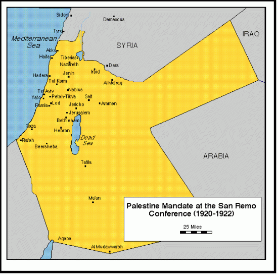
Here is a map of the British Mandate of Palestine (the British ruled Palestine from 1920 to 1948. In 1922 the League of Nations approved the British Mandate of Palestine):

Israel was built up out of the bigger part of the land west of the Jordan river than the West Bank and Gaza. But that does not mean that Israel was built up out of the bigger part of Palestine. In 1921 the British devided the Mandate of Palestine in two parts: The land west of the Jordan which was referred to as Palestine, 23% of the Mandate of Palestine. And the land east of the Jordan, reffering to as Transjordan, 77% of the Mandate of Palestine.

But this crooked use of the term Palestine might have a totally different reason. The Palestinian cause, the cause of several terrorist organisations, is to free Palestine. So they refer to the land controlled by Israel as Palestine. And they do not intend to free Jordan from the Hashemite regime. Only because Israel is Jewish and the Hashemite regime is Muslim.
It is quite intriguing that Arafat in 1964 refered to Israel as Palestine and not to the Jordanian controlled West Bank or the Egyptian controlled Gaza. Than – with the Israeli victory in the 1967 war and the following rule Israel rule over the West Bank and Gaza – these lands suddenly became Palestine.
And untill today the Palestinians only call those lands Palestine that are or once where under Israeli control.
Leave a Comment »
Create a free website or blog at WordPress.com.
Entries and comments feeds.
Leave a comment